Rainwater Levels
You might be forgiven for thinking that the stream will flow up through Hughenden Valley this year given the large amounts of rain we have had through the winter period so far. But that may not be the case, and I have enclosed a diagram that may explain things a bit.
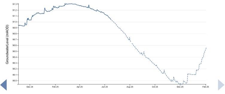
The graph shows the readings for the borehole at the bottom of Cryers Hill between November 2024 and the beginning of February 2026. The borehole has equipment which measures and reports on the groundwater level and that is what we see below. The levels detailed on the left of the graph are what are call datum levels; the figures compare to a reference point. So, for us in the valley, a figure of 90.0 metres shows the groundwater levels here are relatively low and the stream won’t be running in the vicinity of the pumping station.
This graph shows that the highest groundwater figures occur towards the end of winter, typically in February. From looking at the figures, when the reading exceeds 91.0 then the stream is likely to be flowing at the pumping station and also further up through the village from Warrendene. From memory, I believe the stream was flowing in the village from December onwards, which is quite early for it to flow. This shows itself on the graph, where the borehole reading was above 91 in December.
At the beginning of February 2026, the graph is on a steep upward slope, but we are still some way short of the 91 metre figure. Beyond the end of February and assuming we get some relief from this rain, then the stream may not rise at all and we also may not see the groundwater levels putting pressure on the sewage system. Maybe we will not see any sewage discharges this year also.
- Warrendene
The last time we saw Warrendene flooding was 18th December, when again, Warrendene Road became a river. My understanding is that the front of the Harrow was flooded, but that water did not get inside the pub. Since then and despite the large rainfall in recent months, no further flooding of the pub or other property has happened. This goes to show that we can suffer large amounts of rainfall without flooding in the vally, but we simply cannot cope well (at present) with the severe bursts of rain that happen occasionally and which has caused much misery from flooding in the last few years in Warrendene.
- Natural Flood Management Status
We have had a brief update from Andrew Morsley this month on where we are with things:
- The Hughenden Valley project is now on hold while we await the contract to embark on phase 2 – implementation. Bucks Council are holding some budget that needs to be released and Bucks Council have applied for funding from Regional Floods Committee. We will then need to do a prioritisation exercise once we know the budget (we should know in March)
- The feasibility report Andrew prepared for the Bucks Thames Natural Conservation Project will be available soon for public dissemation.
With regard to Bryants Bottom, who are not covered by the NFM project, Hughenden Parish Council have approved a grant for the village to obtain consultancy from Andrew for him to specify potential work to ease the flooding issues seen there. This is being followed up at present.
- WhatsApp Group
It has been suggested that it might be worthwhile setting up a WhatsApp group for residents who see their properties at risk from the different forms of flooding we can see. This might be from hillside runoff, stream issues, sewage spillages etc.
I have seen a bit of interest if forming such a group. The idea would be to use it in exceptional circumstances such as when flooding may be about to happen or, indeed, has already happened. We would seek to use it really only for emergency purposes. Please let me know if you are interested in joining such a group.
Thanks.
Paul Woodford
2 February 2026
